|
|
Post by Neon Rosell II on Feb 1, 2008 22:32:50 GMT
Sir Steve,
Could it be a Striated Swallow in full spread changing directions? The photo is quite over exposed on the upper side obliterating the details but on the opposite side you can still see some striations.
Cheers,
Neon
|
|
|
|
Post by Ding Carpio on Feb 4, 2008 4:35:18 GMT
Just saw this today (my DSL's still down). What a trip! Now I'm thinking how I can convince my family to go again to Sagada for a week. Last time we went was during rainy season about 5 yrs ago and the road cuts and little avalanches on the Halsema Highway (aka Abotion Road) made the road etched on the cliff seem like a scene in an adventure movie.
But us birders have always been known to brave severe environmental conditions just to get a shot of a little lifer, right?
|
|
|
|
Post by Neon Rosell II on Feb 4, 2008 4:44:02 GMT
Just saw this today (my DSL's still down). What a trip! Now I'm thinking how I can convince my family to go again to Sagada for a week. Last time we went was during rainy season about 5 yrs ago and the road cuts and little avalanches on the Halsema Highway (aka Abotion Road) made the road etched on the cliff seem like a scene in an adventure movie. But us birders have always been known to brave severe environmental conditions just to get a shot of a little lifer, right? Ding, The road (Halsema Highway) from Baguio to Mt. Data is all concrete, with just minor road repairs along the way. The stretch from Mt. Data to Banaue is still as you call it abortion road. You can plan a different trip for Banaue and Mt. Polis using the Nueva Viscaya route. Cheers, Neon |
|
|
|
Post by Ding Carpio on Feb 4, 2008 7:30:31 GMT
Yep. Some years back, we did the reverse of what you did: Vizcaya, Banawe, Bontoc, Sagada, Data, Baguio. So we can do just the less-trechearous half. But where's the thrill of not potentially getting killed?  Just saw this today (my DSL's still down). What a trip! Now I'm thinking how I can convince my family to go again to Sagada for a week. Last time we went was during rainy season about 5 yrs ago and the road cuts and little avalanches on the Halsema Highway (aka Abotion Road) made the road etched on the cliff seem like a scene in an adventure movie. But us birders have always been known to brave severe environmental conditions just to get a shot of a little lifer, right? Ding, The road (Halsema Highway) from Baguio to Mt. Data is all concrete, with just minor road repairs along the way. The stretch from Mt. Data to Banaue is still as you call it abortion road. You can plan a different trip for Banaue and Mt. Polis using the Nueva Viscaya route. Cheers, Neon |
|
|
|
Post by Romy Ocon on Feb 4, 2008 7:36:38 GMT
Lolllloooool..... while you're playing tag with the Grim Reaper Ding, you might as well spring for a 500 f4 IS too without telling the better half.... perfect weapon for the Cordillera trip, at the same potential penalty.  But where's the thrill of not potentially getting killed? |
|
|
|
Post by Teddy Regpala on Jun 12, 2008 0:02:53 GMT
HIGHEST PHILIPPINE HIGHWAY. As the banged up sign says, this portion of the Halsema Highway at Atok, Benguet Province is the highest point (Elev. 2256 m/7400 feet) of the Philippine Highway System. This is where I stop and calibrate my altimeter. 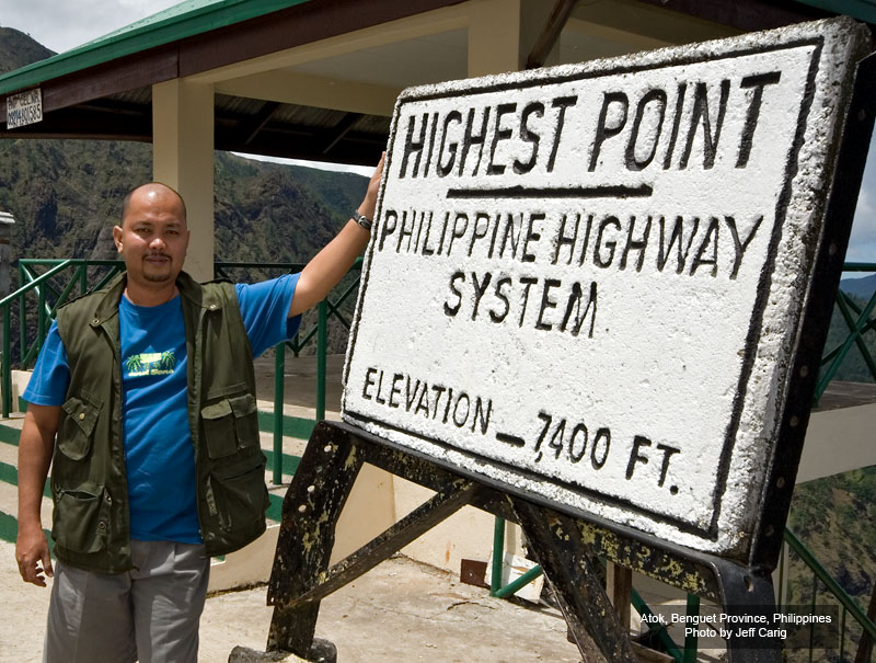 Ka Romy, I've been there on that exact spot. Maybe 1993 or 1994, when I was still with the AI Camera Club. I used to have (oh wait, I still have that) the Nikon F90 with MF-26 ... my first venture with the hobby. Unfortunately, I don't know where my prints are from that trip anymore. |
|
|
|
Post by Romy Ocon on Jun 12, 2008 9:02:19 GMT
HIGHEST PHILIPPINE HIGHWAY. As the banged up sign says, this portion of the Halsema Highway at Atok, Benguet Province is the highest point (Elev. 2256 m/7400 feet) of the Philippine Highway System. This is where I stop and calibrate my altimeter. Ka Romy, I've been there on that exact spot. Maybe 1993 or 1994, when I was still with the AI Camera Club. I used to have (oh wait, I still have that) the Nikon F90 with MF-26 ... my first venture with the hobby. Unfortunately, I don't know where my prints are from that trip anymore. There's a vendor beside the viewdeck at this highest point who hawks the best balut I've tasted in my life. ;D |
|
|
|
Post by Teddy Regpala on Jun 12, 2008 17:22:28 GMT
There's a vendor beside the viewdeck at this highest point who hawks the best balut I've tasted in my life. ;D Whoa! I didn't notice there's a view deck in the background. Just saw the sign and the nice looking gentleman in the foreground. I'm pretty sure, when we were there, there's only a small "hut", like a small waiting shed. And the road was rough (or maybe there used to be some asphalt). On our way there, we ate lunch at one restaurant (turo-turo-style), and they serve only wild rice. That's what they eat around there for local consumption. They refuse to plant the genetically-engineered species developed in Los Banos/IRRI (does it still exist?). They want to preserve it, so they always have grains to plant come planting season. Just a piece of advice, put on some protection "up" there ... you don't want to be called a "red-head". LOL. Regards. |
|
|
|
Post by tina mallari on Feb 18, 2009 15:08:24 GMT
|
|
|
|
Post by Romy Ocon on Feb 18, 2009 20:18:33 GMT
|
|
|
|
Post by tina mallari on Feb 19, 2009 1:54:44 GMT
Thanks a lot Romy. Those 2 birds are the easiest birds to photograph in that area. The mountain shrikes (one couple) are not scared of people and looks like they are building a nest coz one of them keeps on getting nesting materials and bringing it in one area lang. For sure you will get it full frame. The elegant tits naman are super plenty and they keep on displaying themselves right in front of me... sometimes way too near for my 400mm so all i can do is look at them with a crazy smile on my face  Daliiiii head back to Mt.Data na. The weather is fantastic. While we were there, the sun was always shinning and blue skies pa. Would love to go there again |
|
|
|
Post by Toto Gamboa on Feb 19, 2009 4:42:44 GMT
wow .. nice place ma'am tina. any info on how to get there? gps waypoints? routes? must be a good place for summer getaway! |
|
|
|
Post by tina mallari on Feb 19, 2009 11:49:35 GMT
Sorry Toto, low tech person here. We just asked for directions (from other photographers before heading to that place) and that's it. Not a hard place to go to coz there is only one road that goes to that place when you exit from the la trinidad route out of Baguio |
|
|
|
Post by Toto Gamboa on Feb 19, 2009 14:47:28 GMT
Not a hard place to go to coz there is only one road that goes to that place when you exit from the la trinidad route out of Baguio great ... that would be enough tnx! |
|
|
|
Post by Ding Carpio on Feb 19, 2009 21:26:16 GMT
About how long is the drive nowadays from Baguio to Mt. Data?
|
|
|
|
Post by Romy Ocon on Feb 19, 2009 22:13:26 GMT
About how long is the drive nowadays from Baguio to Mt. Data? About 6 hours when your camera is beside you and ready to use, or 2.5 - 3 hours easy driving if you keep your camera and binos in their bags. ;D ;D |
|
|
|
Post by Romy Ocon on Feb 19, 2009 22:18:07 GMT
Thanks a lot Romy. Those 2 birds are the easiest birds to photograph in that area. The mountain shrikes (one couple) are not scared of people and looks like they are building a nest coz one of them keeps on getting nesting materials and bringing it in one area lang. For sure you will get it full frame. The elegant tits naman are super plenty and they keep on displaying themselves right in front of me... sometimes way too near for my 400mm so all i can do is look at them with a crazy smile on my face Daliiiii head back to Mt.Data na. The weather is fantastic. While we were there, the sun was always shinning and blue skies pa. Would love to go there again If you recall, I was smitten by Mt. Data (and the Cordilleras in general) on my first climb 3 years ago - cool air, amazing sceneries, and the place is a mother lode of lifers for us lowlanders. You're right, it's time for me to go back to the place. |
|
|
|
Post by mantarey on Feb 19, 2009 22:54:57 GMT
Thanks a lot Romy. Those 2 birds are the easiest birds to photograph in that area. The mountain shrikes (one couple) are not scared of people and looks like they are building a nest coz one of them keeps on getting nesting materials and bringing it in one area lang. For sure you will get it full frame. The elegant tits naman are super plenty and they keep on displaying themselves right in front of me... sometimes way too near for my 400mm so all i can do is look at them with a crazy smile on my face Daliiiii head back to Mt.Data na. The weather is fantastic. While we were there, the sun was always shinning and blue skies pa. Would love to go there again If you recall, I was smitten by Mt. Data (and the Cordilleras in general) on my first climb 3 years ago - cool air, amazing sceneries, and the place is a mother lode of lifers for us lowlanders. You're right, it's time for me to go back to the place. I've been dreaming about those endemic lifers waiting for us in this beautiful place. I surely won't refuse an invite to this bird haven. Mastah Romy, I want to be smitten too.  |
|
|
|
Post by Neon Rosell II on Feb 20, 2009 2:09:27 GMT
Beautiful set Tina!! Finally you made it there!! And on your first try you got the Mt. Shrike!! The most detailed photo to boot!! On my 2 tries, never did I get to see nor get even a glimpse of this bird, and to think my target species for the two trips was this bird.  . And you know what that means..hehehehe ;D. I'd go back anytime if possible . For guys who want to spend the weekend there, what I do is leave Manila at around 10-11pm of a Friday, arrive Baguio around 4-5am take a short nap and eat breakfast. At around 5:30 leave for Mt. Data. With this times I'll be able to reach the "birdable" portion of the Halsema Highway when light is already sufficient. I'll reach Mt. Data Hotel at around 10-11am, check-in, eat lunch, siesta till 2:30pm and bird till the sun sets. The next day bird from first light till around 10-11am eat brunch and head for home. Make sure you make a lot of rest stops (birding stops) to keep you awake and alert. And one Berocca tablet will work wonders and keep you alert for a whole day. A word of caution, I've said this several times and I'll say it again, Just be careful when stopping. When you see a bird don't just hit the breaks, look behind if there is a car following, signal that you're stopping and slowly apply the breaks. Don't stop if there is a blind curve, make sure cars coming from both directions can see you at a considerable distance. Same thing with parking your car along the road, there is not much space and location along this zigzag highway to safely park your car. Always safety first!!! There is always a next time and place to catch the birds that you'll miss!! |
|
|
|
Post by Toto Gamboa on Feb 20, 2009 2:22:54 GMT
And one Berocca tablet will work wonders and keep you alert for a whole day. does this really work? I have heard about this but havent tried. i should try this. |
|


 , AFS 18-135mm f/3.5-5.6G , TC 1.4EII, TC 1.7EII, SB-800, Manfrotto 190CXPro3/393(3421), RRS BH-55, Kirk NC300 lens collar


 . And you know what that means..hehehehe ;D.