|
|
Post by Ding Carpio on May 20, 2009 2:07:13 GMT
Yes, I do have a crude GPS on my phone so please send me the GPS route. I guess as long as I get to the Pantabangan-Canili road, I can make it to Baler. I assume it’s just one road? Now, the question is how to get to the Pantabangan-Canili road. Should I go to Palayan and head north past Rizal? Or, coming from Cabanatuan, skip Palayan altogether, head north to San Jose then turn somewhat southeast heading for Rizal where, along the way, I assume I’ll find the Pantabangan-Canili road? Would I find signs along the way? As I understand it, I will first need to make my way to Palayan and, from there, I have the option of taking two routes. Now, this is where I’m a bit thick. When I look at Google Earth and the maps I just got from National Bookstore, I see only one road from Palayan going northeast to Bongabon. Does the 2nd route you mentioned pass through Bongabon, too, or does it take a different route to Baler? On maps, I only see one road to Baler coming from the west, and that’s from Bongabon. You mentioned Natividad and Rizal. Natividad seems to turn back west from Palayan while Rizal goes north from Palayan, passing thru Bongabon. Pantabangan and Casili seem to be further up north, beyond Rizal. So the route I can see (in maps) would be Cabanatuan-Palayan-Bongabon-Baler. Help! Hi Ding, I have checked and old map and I cant see the Canili-Pantabangan route. I am guessing that the Canili route isn't shown there as it is relatively new and not a well established route since 2005. Everybody used to pass thru Cabanatuan-Palayan-Bongabon-Villa route to Baler. But that route was destroyed by a super typhoon in 2005 in think. Forgot the name of the typhoon that time. I think it was Ruping. Now the easier route is the Canili-Pantabangan. Less zigzag but more of ascent-descent type of road. Canili-Pantabangan is way up north than Bongabon. Natividad is on your left (western side) when you are going up to Rizal while Bongabon is on your right. However, you wont be passing thru the Bongabon road you are probably seeing in the map, (i assume it is a long straight line from the west to east in the map then you got the zigzags) when you take up the Canili-Pantabangan. Hope this helps. I have a GPS route to Baler both using the Canili-Pantabanagn or the Villa route. I can send them to you if you have a GPS. |
|
|
|
Post by Romy Ocon on May 20, 2009 2:10:09 GMT
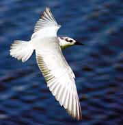
Not this time. The Pantabangan Dam route is much more economical for them. Actually, we have requested that the return route be the "Villa Aurora" route so we can do some bird photography on the way back; the organizers have not acceded. The 5-hour drive through the Pantabagan Dam route is easy driving; however, there is a 35 kilometer unpaved portion as one crosses the Castaneda, Nueva Viscaya portion. oh ic. sayang ... the pantabangan canili area is heavily denuded already. so birding on the way to baler and on the way back to manila is not possible? Yes, the Rizal-Pantabangan-Nueva Vizcaya-Ma. Aurora-Baler route, where buses ply, is heavily denuded and offer very little opportunity for birding. Many sections of the road are rough and hence bumpy/dusty. |
|
|
|
Post by Neon Rosell II on May 20, 2009 2:14:52 GMT
The easiest to go there, since you have your own car, is to take the Bongabon baler route, it's the shorter path as well. Then go back through the Pantabangan-Canili way.. ;D
|
|
|
|
Post by Romy Ocon on May 20, 2009 2:15:52 GMT
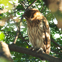
Nooooooo, Ding..... don't use the Rizal- Pantabangan route, no birds there!! Take the Cabanatuan-Palayan-Bongabon-Baler route, where there is still forest along the trail. This is where Neon, Tina, Rey, Sylvia/Tonji and I birded. Birding starts at km 155 and extends for at least 60 km. Yes, I do have a crude GPS on my phone so please send me the GPS route. I guess as long as I get to the Pantabangan-Canili road, I can make it to Baler. I assume it’s just one road? Now, the question is how to get to the Pantabangan-Canili road. Should I go to Palayan and head north past Rizal? Or, coming from Cabanatuan, skip Palayan altogether, head north to San Jose then turn somewhat southeast heading for Rizal where, along the way, I assume I’ll find the Pantabangan-Canili road? Would I find signs along the way? Hi Ding, I have checked and old map and I cant see the Canili-Pantabangan route. I am guessing that the Canili route isn't shown there as it is relatively new and not a well established route since 2005. Everybody used to pass thru Cabanatuan-Palayan-Bongabon-Villa route to Baler. But that route was destroyed by a super typhoon in 2005 in think. Forgot the name of the typhoon that time. I think it was Ruping. Now the easier route is the Canili-Pantabangan. Less zigzag but more of ascent-descent type of road. Canili-Pantabangan is way up north than Bongabon. Natividad is on your left (western side) when you are going up to Rizal while Bongabon is on your right. However, you wont be passing thru the Bongabon road you are probably seeing in the map, (i assume it is a long straight line from the west to east in the map then you got the zigzags) when you take up the Canili-Pantabangan. Hope this helps. I have a GPS route to Baler both using the Canili-Pantabanagn or the Villa route. I can send them to you if you have a GPS. |
|
|
|
Post by Ding Carpio on May 20, 2009 3:21:03 GMT
Done! Will take the Bongabon-Baler route going there then. Will leave Manila earlier than the buses so I can take my time. Hope my passengers will not get bored.
I take it that the road is safe? i.e. no political friendlies asking for tax? Could my Sta. Fe take the bumps?
|
|
|
|
Post by Romy Ocon on May 20, 2009 4:13:26 GMT
Done! Will take the Bongabon-Baler route going there then. Will leave Manila earlier than the buses so I can take my time. Hope my passengers will not get bored. I take it that the road is safe? i.e. no political friendlies asking for tax? Could my Sta. Fe take the bumps? Yes, the road is safe, politically that is.  You don't need a 4x4 for the road, but a higher clearance vehicle will allow you to skim freely over rocks on the trail. If you only have one spare tire, I suggest you bring both the following for rendundant safety: 1. Air compressor 2. Aerosol flat tire fixer/sealer/inflater The worst problem you can face in the trail (aside from jumping over a cliff) is two flat tires - spotty cfone signal, very few passing vehicles, and no vulcanizing service along the 60 km road can spell massive inconvenience. Also, fill up your fuel tank at Cabanatuan, as gas/diesel is very expensive at Baler and availability at Bongabon is erratic. A full tank at Cabanatuan should be enough for you to bird the trail, travel all over Aurora, and get back to Cabanatuan. Another important thing - before leaving the Bongabon concrete road (km 150 - 155), stop and ask the residents if the route to Baler is open. Sometimes, a landslide or a downed huge truck can block the road. Tough to experience a stranding after you've traveled two hours worth of mountain driving. The latter happened to me on my way back home so we've to return to Baler and re-route via Pantabangan. Reposting here one of the better sections of the 60++ km Bongabon-Baler Road:  |
|
|
|
Post by Toto Gamboa on May 20, 2009 4:30:00 GMT
Agree with Master Romy ... you have a high chance of getting lost using the Pantabangan-Canili route and less birding opportunities. The bongabon road is easy to find. It is the only road once you get to Bongabon. I'll send the GPS route later when i get home Now that it is certain that the bus will not take the Villa route where birding could be very abundant, this increases the chances that I would want to drive up there too. I'll have the decision by tomorrow. If I decide to drive, I might as well drive the Villa route with you Ding. |
|
|
|
Post by Romy Ocon on May 20, 2009 4:36:08 GMT
Agree with Master Romy ... you have a high chance of getting lost using the Pantabangan-Canili route and less birding opportunities. The bongabon road is easy to find. It is the only road once you get to Bongabon. I'll send the GPS route later when i get home Now that it is certain that the bus will not take the Villa route where birding could be very abundant, this increases the chances that I would want to drive up there too. I'll have the decision by tomorrow. If I decide to drive, I might as well drive the Villa route with you Ding. It will be ideal if you can afford to bring your own vehicle, and just join the main group at the Baler end. Bird photography in a large group is oftentimes cumbersome. Driving in a convoy minimizes safety issues too - when one vehicle suffers multiple flat tires or an engine trouble, the other one can run for assistance. |
|
|
|
Post by Jun Gregorio on May 20, 2009 5:23:20 GMT
Being from Gapan City, NE. This thread makes me really wish I was there. It's really really making me jealous.
One question though. With a group this size. Does anyone use FRS radios? or is it legal to use FRS 2-way radios in the Phil.?
|
|
|
|
Post by Toto Gamboa on May 20, 2009 5:52:52 GMT
Ok am decided na rin to drive up there as well. Sabay na lang ako sir Ding I like the suggestion of Master Romy. We should be at the foot of the mountain ranges in Bongabon around 6am so we can do birding Leaving around 2am is cool to me. |
|
|
|
Post by Dennis Alfaro on May 20, 2009 6:12:51 GMT
Ok am decided na rin to drive up there as well. Sabay na lang ako sir Ding I like the suggestion of Master Romy. We should be at the foot of the mountain ranges in Bongabon around 6am so we can do birding Leaving around 2am is cool to me. sir toto, if you don't mind, can i join with you? newbie lang talaga |
|
|
|
Post by Francis Cadiente on May 20, 2009 6:28:00 GMT
Sir Toto can I also join you?
|
|
|
|
Post by Toto Gamboa on May 20, 2009 6:31:27 GMT
sure Den and Francis. tamang tama since I can only accomodate 2 pax. |
|
|
|
Post by Agerico M. De Villa on May 20, 2009 13:16:33 GMT
Correction please: I said my wife, Jenny, is coordinating everyone "tomorrow." I am leaving tomorrow for Baler,Thursday, 21 May. My wife is meeting everyone at the Genesis bus station and leaving with everyone on Friday, 22 May. Pasensiya na.
|
|
|
|
Post by Ding Carpio on May 20, 2009 14:18:36 GMT
Ok am decided na rin to drive up there as well. Sabay na lang ako sir Ding I like the suggestion of Master Romy. We should be at the foot of the mountain ranges in Bongabon around 6am so we can do birding Leaving around 2am is cool to me. Ok. We'll convoy then! I plan to leave around 2am but let me confirm by tomorrow afternoon. I have wife, 2 kids, and 2 nieces who are tough to extricate from beds so will have to talk to them seriously about promptness. Someone asked about FRS radios. Not sure if legal but I use it all the time. I have a bunch of 3 (lost one in Candaba) which I'll bring. Useful in convoys. Those who will convoy, suggest we PM each other's cell numbers. We can all plan to meet at some service station in NLEX or, so we can dictate our own pace in the highway, somewhere in Cabanatuan. |
|
|
|
Post by Ding Carpio on May 20, 2009 14:22:18 GMT
Correction please: I said my wife, Jenny, is coordinating everyone "tomorrow." I am leaving tomorrow for Baler,Thursday, 21 May. My wife is meeting everyone at the Genesis bus station and leaving with everyone on Friday, 22 May. Pasensiya na. Prop, before you leave: Just to reconfirm, I'm taking that room you somehow managed to get for my family. Paki-PM na lang where it is. Thanks. |
|
|
|
Post by Toto Gamboa on May 20, 2009 14:29:25 GMT
Pm'd you my number sir Ding. I'll email the GPS route later. As for 2am ETD, we will just have to adjust based on your time.
|
|
|
|
Post by Ding Carpio on May 20, 2009 14:40:43 GMT
On itinerary, does someone have it? Or is it bahala when we get to Baler? I'm also unclear about rooming accomodations. Or would my questions be answered at the WBCP forum? There are so many threads there and, at least from my PC, the Yahoo threading engine seems buggy and tough to navigate.
|
|
|
|
Post by alainpascua on May 20, 2009 18:05:38 GMT
Hi Ding!
Sent you the Baler schedule via email. Please check it out.
Also, I will PM you my celfone as I will be riding in the bus, so we can just coordinate with each other.
In Baler, I will be joining the PBPF group.
Thanks and see you there!
Alain
|
|
|
|
Post by tina mallari on May 20, 2009 22:01:17 GMT
Ohhhhhhh and just to make sure that you do not take Romy's tip about the tires for granted...
Wency and I had a flat tire and it was a BIG relief that Tonji was there to help us. There were 2 nails embedded in our tire. We had an air compressor with us but that didn't help because of the type of puncture we got. One of the nails was hidden in between the grooves of the tire so they weren't able to see it.
Have FUN and may you guys be blessed with beautiful weather.
|
|


 As I understand it, I will first need to make my way to Palayan and, from there, I have the option of taking two routes. Now, this is where I’m a bit thick. When I look at Google Earth and the maps I just got from National Bookstore, I see only one road from Palayan going northeast to Bongabon. Does the 2nd route you mentioned pass through Bongabon, too, or does it take a different route to Baler? On maps, I only see one road to Baler coming from the west, and that’s from Bongabon.